Students Visualize Structures of Oppression; win NC State Envisioning Research Contest
Students in the College of Design recently took top prizes in the Graphics and Data Visualization and Photography categories of the NC State Envisioning Research Contest.
The contest is a collaborative effort by NC State’s Office of Research and Innovation, the Graduate School, the NC State University Libraries, the Office of Undergraduate Research and University Communications and Marketing. Envisioning Research was open to faculty, staff, graduate students, postdoctoral researchers and undergraduates.
Ben Coleman, Susmita Patil, and Sophia Li all submitted entries from Tania Allen and Sara Queen’s class: DIY Cartography: Oppressive Infrastructures. The class explored how we as a society are grappling with how to best serve diverse communities and create more equitable futures for all while visualizing the complex historic context around oppressive infrastructures in the US.
Steven Chavez, a student practitioner in the Doctor of Design program, submitted Urban Waterway Viewshed, which hopes to influence the reprogramming of urban river bridges to include being multipurpose destinations rather than single-purpose crossings.
Graphics and Data Visualization Winners
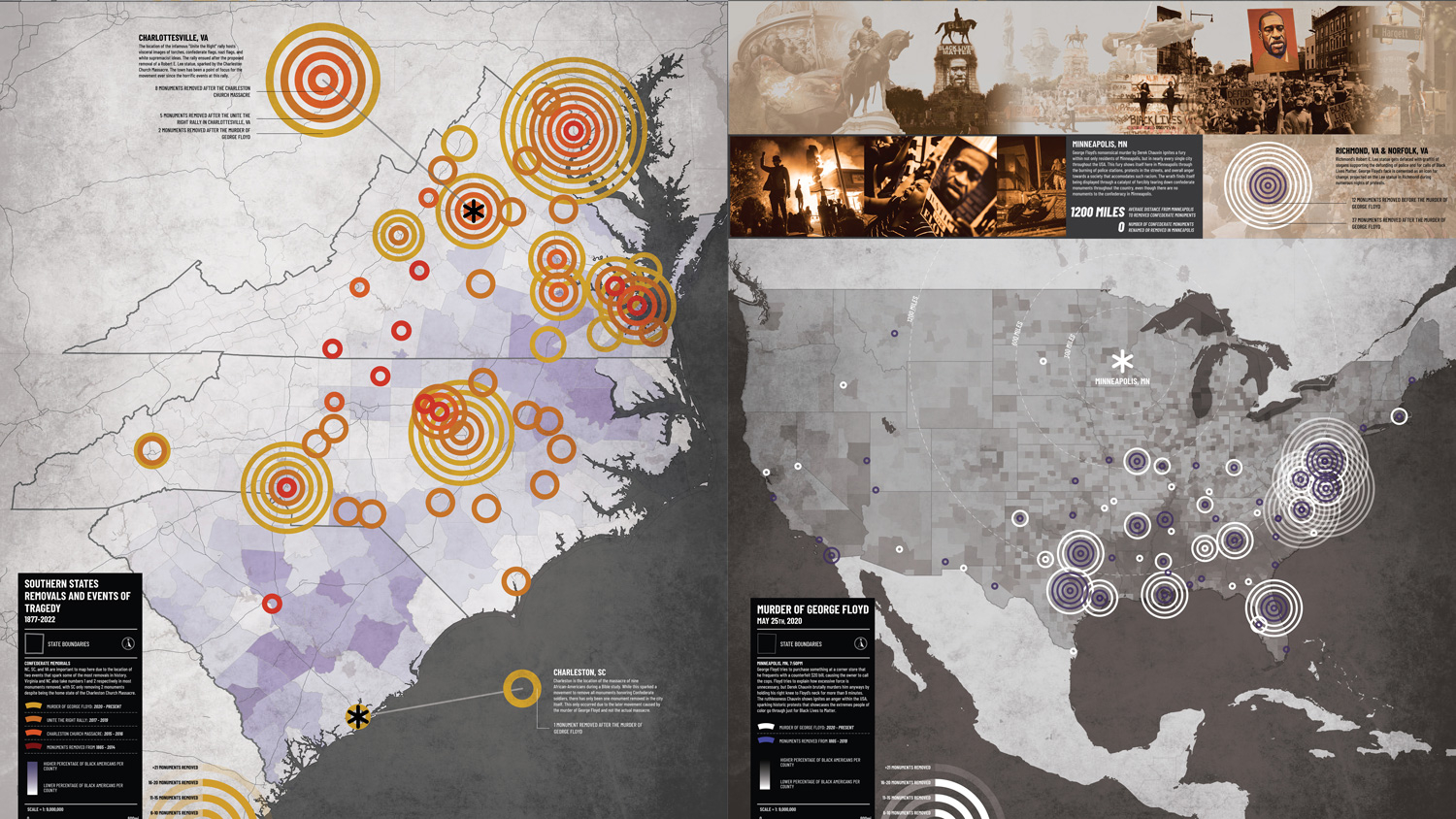
First Place, Graduate Students and Postdocs: Ben Coleman, a graduate student in the College of Design, for “Action Taken From Tragedy.”
Second Place, Graduate Students and Postdocs: Susmita Patil, a graduate student in the College of Design, for “Railroads of the Confederacy.”
First Place, Undergraduate Students: Sophia Li, an undergraduate in the College of Design, for “Growing Pains: Gentrification in South Park, Raleigh NC.”
Photography Winners
Honorable Mention, Graduate Students and Postdocs: Steven Chavez, a Doctor of Design student in the College of Design, for “Urban Waterway Viewshed.”
See the Winning Entries
Ben Coleman – Action Taken from Tragedy
First Place: Graduate Students and Postdocs, Graphic and Data Visualization
Masters of Architecture Student
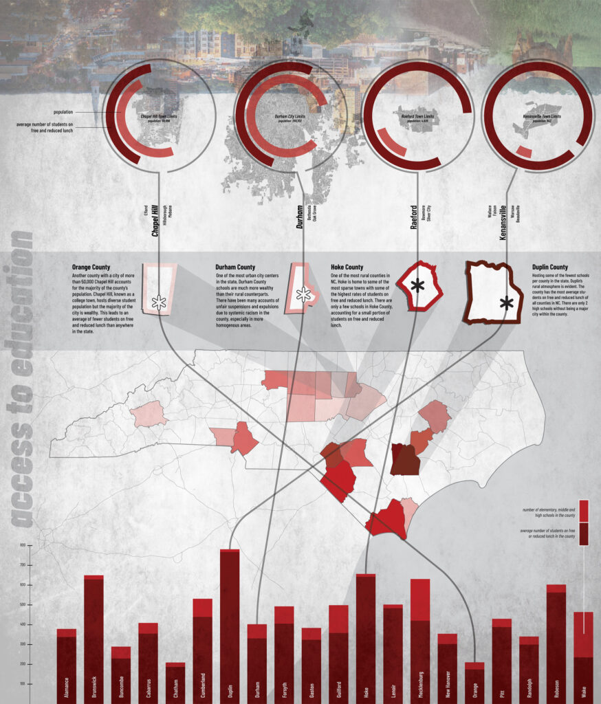
The horrific events of the 2015 Charleston, SC Massacre, the 2017 Charlottesville, VA Unite the Right Rally, and the 2020 murder of George Floyd in Minneapolis, MN are mapped in relation to reactionary monument removal across the US visualizing how these tragedies sparked nation-wide outcry against racist ideologies perpetuated throughout the country and embodied in the confederate monuments. This reactionary monument removal is contextualized in a broader history of systemic racism by visualizing racial diversity and wealth through school demographics to highlight educational and economic inequity patterns within communities that have removed confederate monuments vs those that have not.
Susmita Patil – Railroads of the Confederacy
Second Place: Graduate Students and Postdocs, Graphic and Data Visualization
Master of Architecture Student
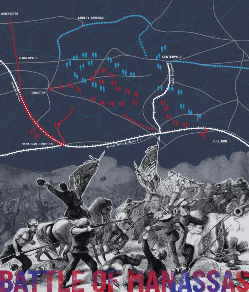
The first railroad opened in 1827 and by the 1840s rail networks connected all major US cities. During the Civil War, railroads were an important factor in transporting logistical support to the troops and were vital to the economies of the divided nation. Railroads played an important role in deciding where the battles were fought and where the troops and materials were moved. Some of the longest railroads were built in the South and nearly all of them were constructed with slave labor. These maps visualize the growth and change in the railway systems from 1840 to 2017. These maps highlight the importance of rail during the Civil War for major Confederate cities and battlefields. They collectively suggest a connection between confederate railroad lines and where monuments were erected over time.
Sophia Li – Growing Pains: Gentrification in South Park, Raleigh, NC
First Place: Undergraduate Students, Graphic and Data Visualization
Bachelor of Architecture Student
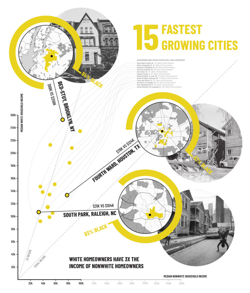
American cities are rapidly growing and re-development quickly follows it. However, growth often impacts historic, local communities near downtown expansion areas. The developments frequently decimate low-income, predominantly minority neighborhoods near the city center which silences and erases displaced residents. Over the last two decades, the economic and demographic change associated with gentrification has accelerated. Suburbs now grow more diverse as Hispanics, Asian-American, and African-American families are pushed out of city centers. South Park, a historically black neighborhood directly south of Downtown Raleigh, is undergoing demographic change as white neighbors move in, ushering in higher home prices and increased property taxes while displacing long-term residents.
Steven Chavez – Urban Waterways
Honorable Mention, Graduate Students and Postdocs, Photography
Doctor of Design Student Practitioner
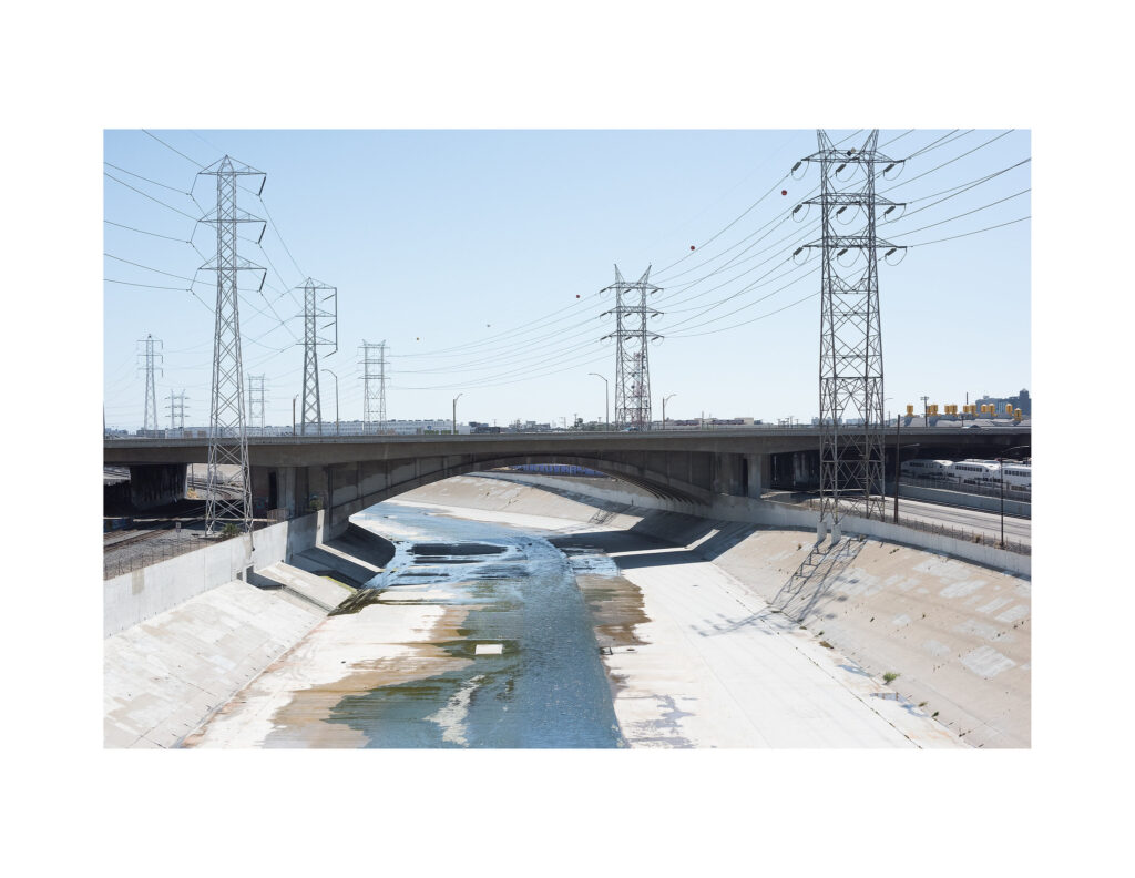
Steven’s research in the DDes Program at NC State is based on urban waterways. This photograph was taken from a bridge crossing the highly urbanized Los Angeles River. The purpose of the photograph is to bring attention to the unique beauty of urban waterways to hopefully influence the reprogramming of urban river bridges to include being multipurpose destinations rather than single-purpose crossings.
This post was originally published in College of Design Blog.